

We picked one neighborhood, Arcadia in Phoenix, Arizona, and asked two frontier models to profile it as a prospecting territory: how many homes, what they're worth, who lives there, how many households are worth an advisor's time. Both answered with confident, well-organized numbers. Then we pulled the public record for the same four square miles and checked every figure.
Neither model simply made things up. What they did is harder to catch, and it matters more for how you'd use one of these answers. Our guide to AI prospecting for financial advisors covers the comparison method in full; this post is the worked example behind it.
unknown nodeWhat we ran
On 2026-08-19 we sent the same one-line prompt to two models from an empty directory: "Profile the Arcadia neighborhood in Phoenix, Arizona for me as a prospecting territory. I'm a financial advisor. Give me the numbers: how many homes, what they're worth, who lives there, and how many households would be worth my time." Claude Opus 5 ran through the Claude Code CLI with every file, search, and browsing tool disabled, so it had nothing but its training. GPT-5.6 ran through the Codex CLI in a read-only local sandbox.
The runs differed in one way we didn't plan for. GPT-5.6's sandboxed shell lookups failed with a DNS error, but the Codex CLI's built-in web-search tool sat outside that sandbox, and the model used it more than a dozen times, pulling real numbers from Census Reporter. So the useful comparison became an honest blind guess against a model that partly looked things up and presented the result with the same confidence either way. One neighborhood, one date, two models: this is not a claim about AI in general, and we didn't test Gemini or Copilot.
Credit where it's due: the boundary problem
Both models questioned the boundary before giving a number, which a lot of published "neighborhood data" doesn't bother to do.
Claude Opus 5, with no data access, opened its numbers section with this warning: "'Arcadia' gets used loosely and it will wreck your numbers if you don't split it." It split the area into "Arcadia Proper," "Arcadia Lite," and a Scottsdale-side pocket, and flagged that a single ZIP code (85018) would mix three-million-dollar estates with under-$500,000 condos.
The public record backs that instinct. We found five actively used definitions of Arcadia's boundary that agree on none of the three variable edges. Wikipedia draws the neighborhood from 44th to 68th Street (Wikipedia, retrieved 2026-08-19), citing no source. The neighborhood association draws the east edge at Scottsdale Road instead (Arcadia Camelback Mountain Neighborhood Association, retrieved 2026-08-19). Local brokerages split the area into three named sub-markets with different streets again, and one broker's page says outright that "the boundaries of Arcadia seem to move depending on who you ask." A count of "homes in Arcadia" means nothing until you fix a polygon, and no single source fixes it for you.
GPT-5.6 flagged the same thing ("'Arcadia' has fuzzy boundaries") and then made a choice its own text partly disagreed with.
The count: two credible numbers, two different polygons
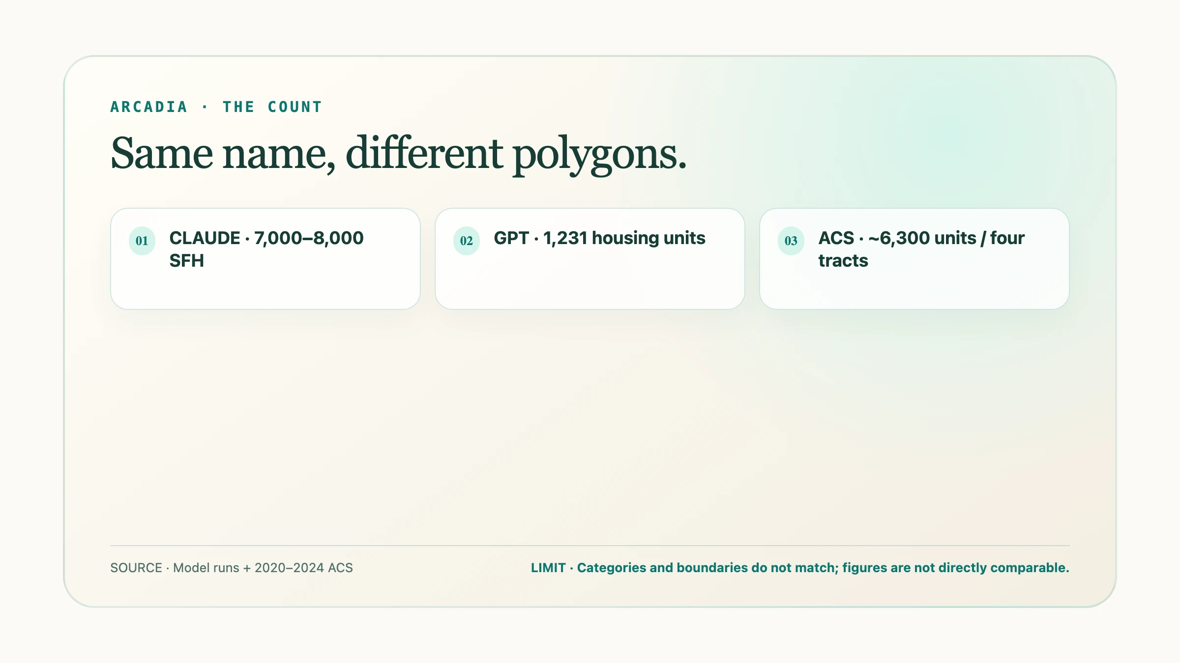
Claude's estimate for the "Arcadia core" (Proper plus Lite) was 7,000 to 8,000 single-family homes, built from general knowledge of comparable Phoenix neighborhoods and labeled "medium confidence."
No census tract is named Arcadia. We geocoded specific Arcadia addresses against the Census Bureau's geocoder to find the four tracts that cover the area (1079, 1080, 1081, and 1082, Maricopa County), then pulled each one's housing-unit count from the 2020–2024 American Community Survey (U.S. Census Bureau geocoder, retrieved 2026-08-19; Census Reporter, a pass-through of the Census Bureau's ACS API, profile for Tract 1080, retrieved 2026-08-19). Total: roughly 6,300 housing units (2,005 + 1,231 + 1,286 + 1,775).
Directionally, the unsourced guess holds up. But Claude's number describes single-family homes in a hand-drawn polygon; the ACS number describes all housing units, condos and multifamily included, in four tracts whose edges don't match that polygon. Comparing them without saying so is exactly the mistake a busy advisor would make skimming either answer.
GPT-5.6 got specific: 1,231 housing units, 1,186 occupied, matching the ACS figures for tract 1080 exactly. It called 1,186 "the conservative, Census-defensible territory count," while noting in the same paragraph that "the broader colloquial Arcadia Proper footprint is likely closer to 2,000 occupied households." Tract 1080 is one of four tracts, and as the next section shows, the wealthiest and least representative one. A correctly sourced number from the wrong polygon is no more trustworthy than a rough one from roughly the right polygon. It's just harder to argue with.
Owner-occupancy: one number erases four markets
Ask either model for the owner-occupancy rate and you get one figure. Claude: roughly 65–70%. GPT-5.6, from tract 1080 alone: 99%, approximately 1,174 of 1,186 households.
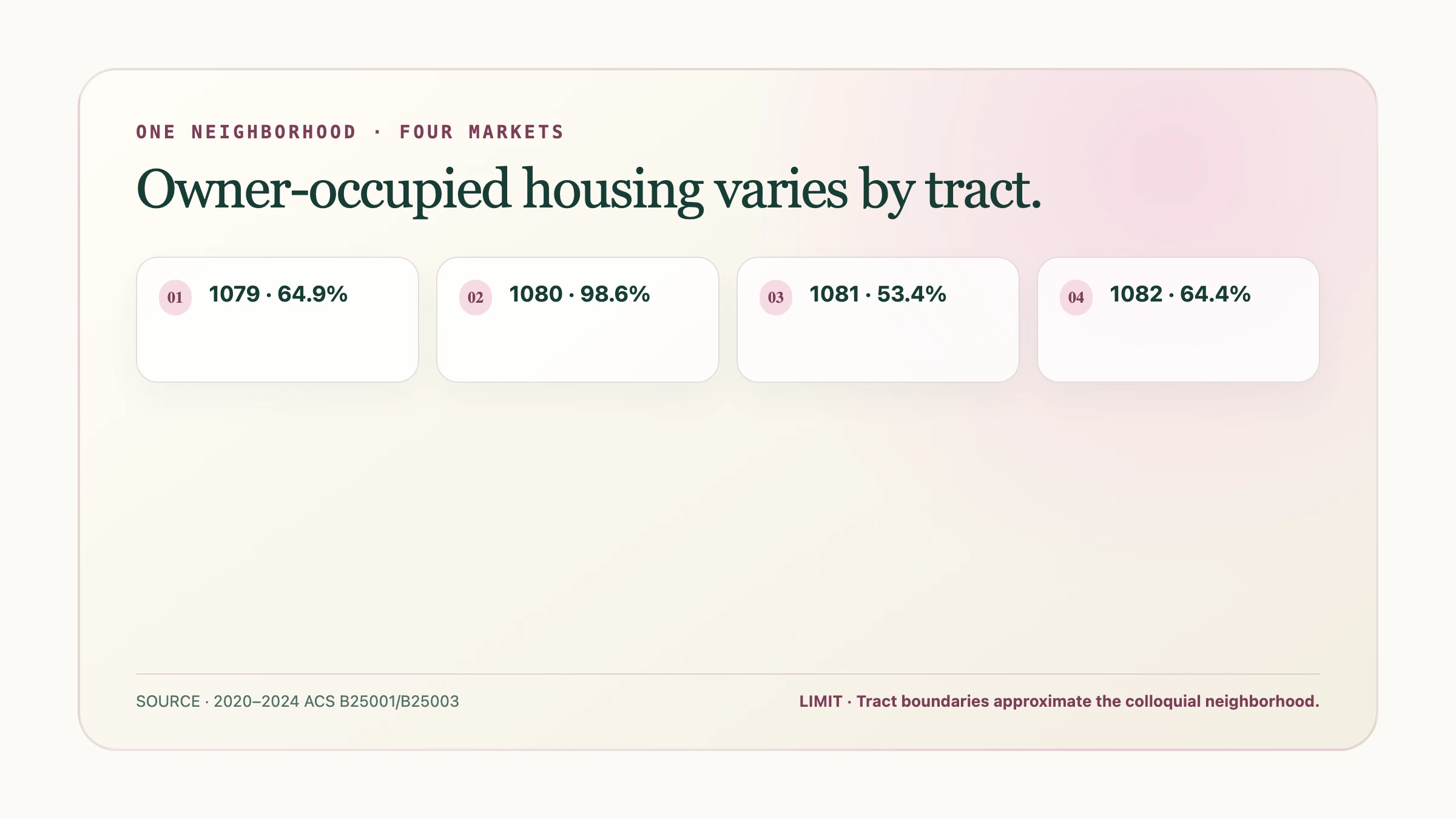
The four tracts, individually:
|
Tract |
Owner-occupied |
|---|---|
|
1079 |
64.9% |
|
1080 |
98.6% |
|
1081 |
53.4% |
|
1082 |
64.4% |
(Source: 2020–2024 ACS 5-year estimates, tables B25001/B25003, via Census Reporter's pass-through of the Census Bureau API, retrieved 2026-08-19.)
Tract 1080 is close to fully owner-occupied. Tract 1081, about a mile away and inside every source's definition of Arcadia, is barely above half. Averaging those, or quoting the highest as if it covered the whole neighborhood, destroys the one fact a territory plan needs: these are different markets sitting next to each other. A mailing list built off "65–70% owner-occupied, Arcadia" would be wrong about the two tracts that matter most.
Top-coding: the most useful thing in this article
GPT-5.6 got this half right and undid it in the next paragraph.
The Census Bureau caps two figures on ACS tables: median household income at $250,000 and median home value at $2,000,000. When a tract's real median exceeds the cap, the published number is the cap plus one dollar, and the Bureau computes no margin of error for it, because it isn't a point estimate. Tract 1080 reports median household income of $250,001 and median home value of $2,000,001. Both are the ceiling, not a measurement.
GPT-5.6 stated this correctly: "Core Arcadia's ACS median owner-occupied home value is reported as $2,000,001. That is effectively a top-coded '$2 million or more,' not a precise valuation." Two paragraphs later, the same run wrote:
unknown nodeThat is a censoring rule multiplied by a unit count and reported as a dollar figure, right after explaining that the number being multiplied isn't real. The hedge doesn't undo the fact that a large, specific number now exists on the page, and a skimming reader will remember $2.46 billion, not the caveat. The "who lives there" section repeats the pattern: median income is labeled "$250,001, the ACS ceiling," then used two rows later to compute "households earning over $200,000: 62%, approximately 735 households."
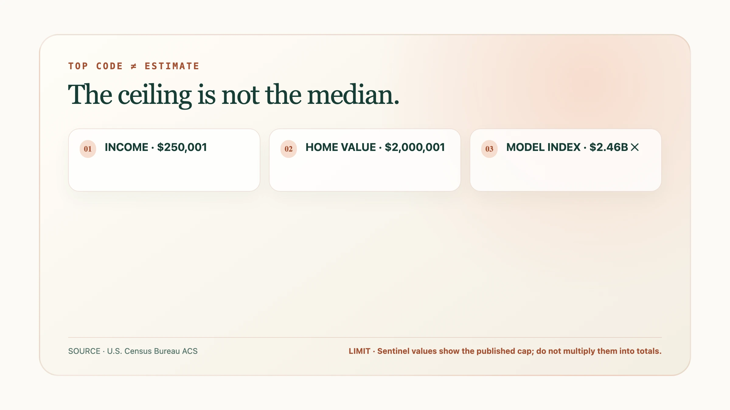
An advisor who pastes "$250,001" into a spreadsheet as Arcadia's median income has recorded a Census Bureau censoring rule as a fact about a neighborhood. Be suspicious of any figure sitting at exactly $250,000 or $2,000,000 plus a dollar.
Margin of error: the number neither model surfaced
Tract 1081's median home value is reported as $889,200, with a margin of error of ±$650,295, or 73% of the estimate itself. By the Census Bureau's own reliability convention, the coefficient of variation works out to roughly 44%, well past the ~30% level the Bureau treats as "use with caution." The true median could plausibly sit anywhere from around $240,000 to well over $1.5 million.
Neither model mentioned a margin of error for any figure. A $889,200 estimate with a ±$650,295 range is a number the Census Bureau's own methodology tells you not to lean on, and a territory plan built on it has no floor.
The forward tax year: both models half right
Both runs warned that assessed value lags market value. Claude's version: "assessor FCV lags real value in Arcadia, sometimes badly." The assessor defines Full Cash Value as "the Assessor's estimate of the property's market value" (Maricopa County Assessor, retrieved 2026-08-19), but it's a mass-appraisal estimate on a delay neither model could size. When we pulled the data, every parcel in the county carried a "current" tax year of 2027: the county was already publishing final values for a tax year that hadn't started. The bill an owner actually pays is capped by a separate figure, Limited Property Value, which can rise at most 5% a year regardless of the market. Full Cash Value is a forward-looking, capped, lagging estimate, not what the house is worth today.
Arizona is not a "non-disclosure state"
This is the finding that changes what an advisor should do next.
Claude correctly named the county assessor as the first free stop for parcel data, then, for sale prices, sent the advisor to ARMLS, the regional MLS: "actual sale prices and days-on-market." ARMLS is gated to licensed real-estate professionals. That advice points a financial advisor at a paywall for data the county already gives away.
Real-estate content sites widely describe Arizona as a "non-disclosure state," with language like "Arizona's status as a non-disclosure state stems from the absence of laws requiring public disclosure of sale prices" (congressrealty.com, retrieved 2026-08-19). We checked that against the county's own systems. Arizona law requires an Affidavit of Property Value on essentially every real property transfer, whose purpose, per the Arizona Department of Revenue, is "to record the selling price, date of sale and other required information about the sale of property" (Wayback Machine snapshot of azdor.gov, dated 2025-12-19). Maricopa County's bulk-data page says its "Sales Affidavits" download "Contains sales data from Sales Affidavits recorded with the Maricopa County Recorder's Office, includes parcel number, grantor, grantee, sales date, and sales price" (Maricopa County Assessor, retrieved 2026-08-19).
We also checked the live system. Querying the assessor's live public parcel service on 2026-08-19 returned real, non-null SALE_PRICE values on Arcadia-area parcels: a residential condo that sold for $390,000 in June 2025, and a commercial shopping-center parcel that sold for $65,800,000 in July 2021. Both are already-public county records, shown to demonstrate what the field returns.
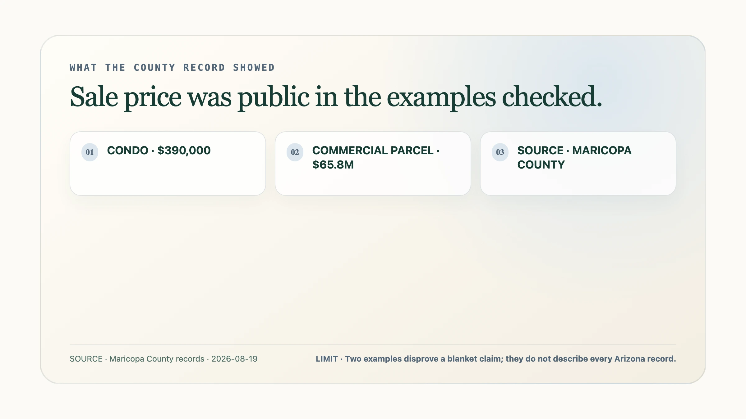
We found no Arizona statute making the affidavit confidential, only the widely copied claim that sale prices "never appear in public records." A model trained largely on real-estate marketing copy has every reason to repeat that folklore with confidence, and that's what happened.
How to read a model's territory number
Neither model was useless. Claude, given nothing, named the assessor as the primary source, flagged mailing address versus situs address as the cheapest signal for absentee ownership, and closed with an unprompted reminder that outreach built from public records still runs under the SEC Marketing Rule or FINRA Rule 2210. GPT-5.6 landed close on a housing-unit count and explained top-coding correctly before building past it. The failure in both cases was a plausible, internally consistent, confidence-labeled answer that the primary sources partly contradict, partly can't confirm, and partly render meaningless, delivered in a register indistinguishable from an answer that checked.
A territory number is only as good as the polygon under it, the margin of error next to it, and whether anyone checked what the source measures. Public records are how you check. A reverse address lookup of who owns a property and where they actually live applies the same discipline to one household instead of a census tract, and our guide to working a territory by assessed value covers building a list once your boundary is fixed. Trusts and LLCs are common at this price point, so plan for them: finding the person behind an LLC-owned property is the next step. Plotbook's free territory teardown handles the definitional half for any place name you type in: which boundary, which jurisdiction, and what a record there can and can't tell you. It carries no parcel data by design, because that half is worth getting right before a dollar figure enters the conversation.
Frequently asked questions
Did the AI models lie about Arcadia's numbers?
No. Neither model invented a statistic or a person. Both produced answers that were internally consistent, hedged in places, and still materially misleading: a single owner-occupancy figure that erased a 53.4%-to-98.6% spread, and a top-coded Census ceiling used as a real median. That's harder to catch than a fabricated number, because nothing in either answer was checkably false on its own.
What is Census top-coding, and why does it matter for prospecting?
The Census Bureau caps certain figures on public tables, most relevantly median household income at $250,000 and median home value at $2,000,000. If a tract's real median exceeds the cap, the published number is the cap plus one dollar (for example, $250,001), with no margin of error, because it isn't a measured value. Doing arithmetic on a top-coded figure produces a precise-looking number built on a statistical artifact.
Is Arizona really a non-disclosure state for home sale prices?
Not in the way the phrase gets used online. Arizona law requires a sale price on nearly every property transfer via a mandatory Affidavit of Property Value, and Maricopa County's assessor publishes that data, including a free bulk "Sales Affidavits" download with grantor, grantee, sale date, and sale price. We confirmed real sale prices on Arcadia parcels directly from the county's public system on 2026-08-19.
How should I define a neighborhood's boundary before pulling data?
Pick one polygon and hold it fixed before you request a single number. Arcadia has five actively used definitions that disagree on all three variable edges, so a ZIP code, a school-district line, or a "locals call it this" boundary will each give you a different home count and median. Decide which one you're using, state it, and keep it constant so later comparisons, including year over year, cover the same ground.