Property Wealth Map
Wealth has an address.
Now it has a map.
Plotbook paints nationwide parcel data from Regrid, covering 150M+ parcels, straight onto an interactive map, every lot colored by its assessed value. Zoom out and curated high net worth areas glow emerald across the country. Zoom in and each parcel wears its assessed-value band and the deed owner's name from the county record. Prospecting stops being a list and starts being a landscape.
The color ramp
Six bands. One glance.
Every parcel is colored by its county-assessed value on a light-to-dark ramp, so a street of eight-figure estates reads differently from a block of starter homes before you have clicked anything. The deeper the blue, the bigger the number.
The legend is one toggle away whenever you need the key, and when you would rather study clean satellite imagery, the colors switch off entirely.
- Unknown
- Under $500K
- $500K – $1M
- $1M – $5M
- $5M – $10M
- Over $10M
The exact bands from the in-product legend. Parcels without a published assessed value show as Unknown rather than wearing a guessed number.
Three altitudes
From the whole country to a single curb
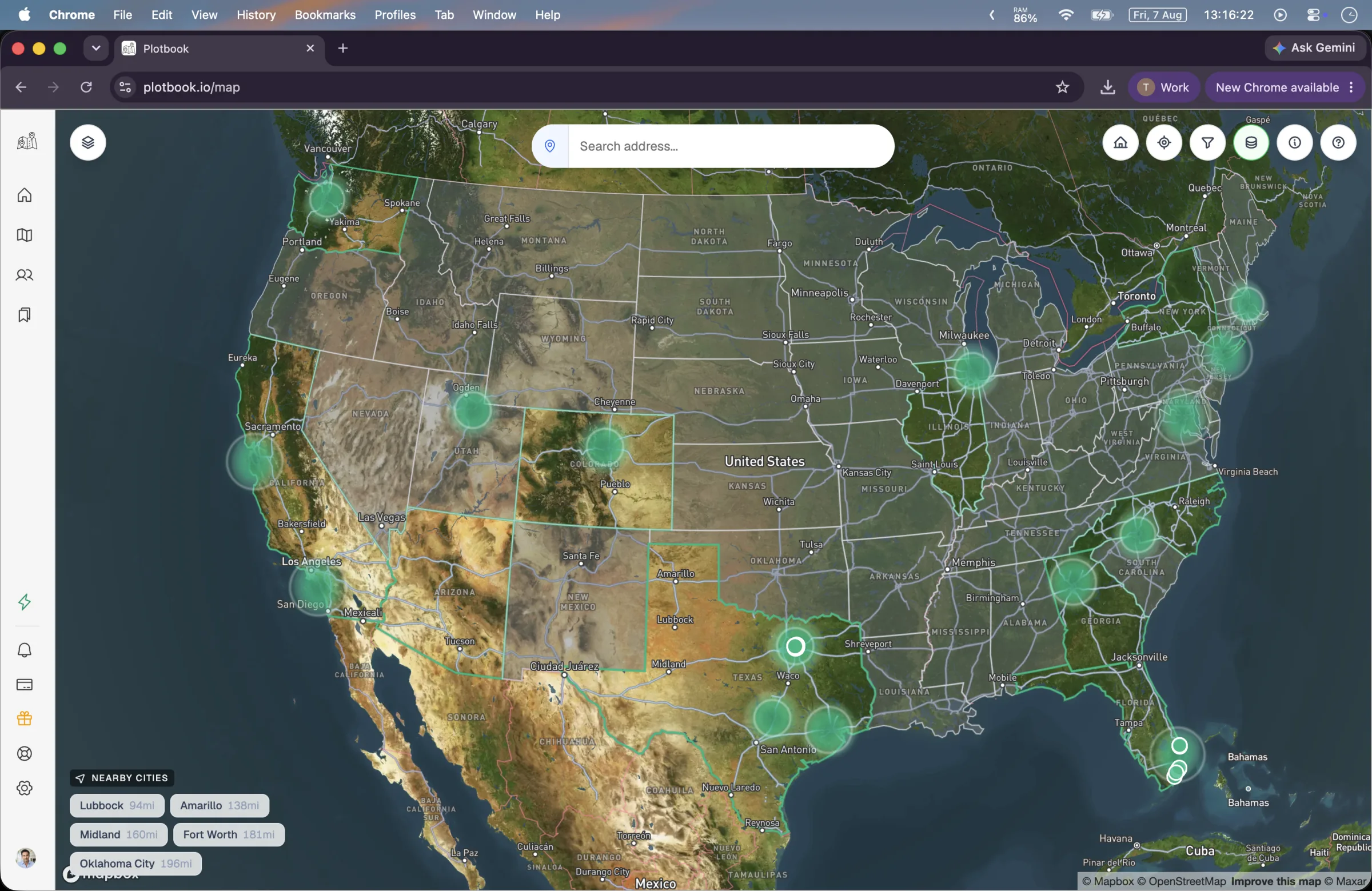
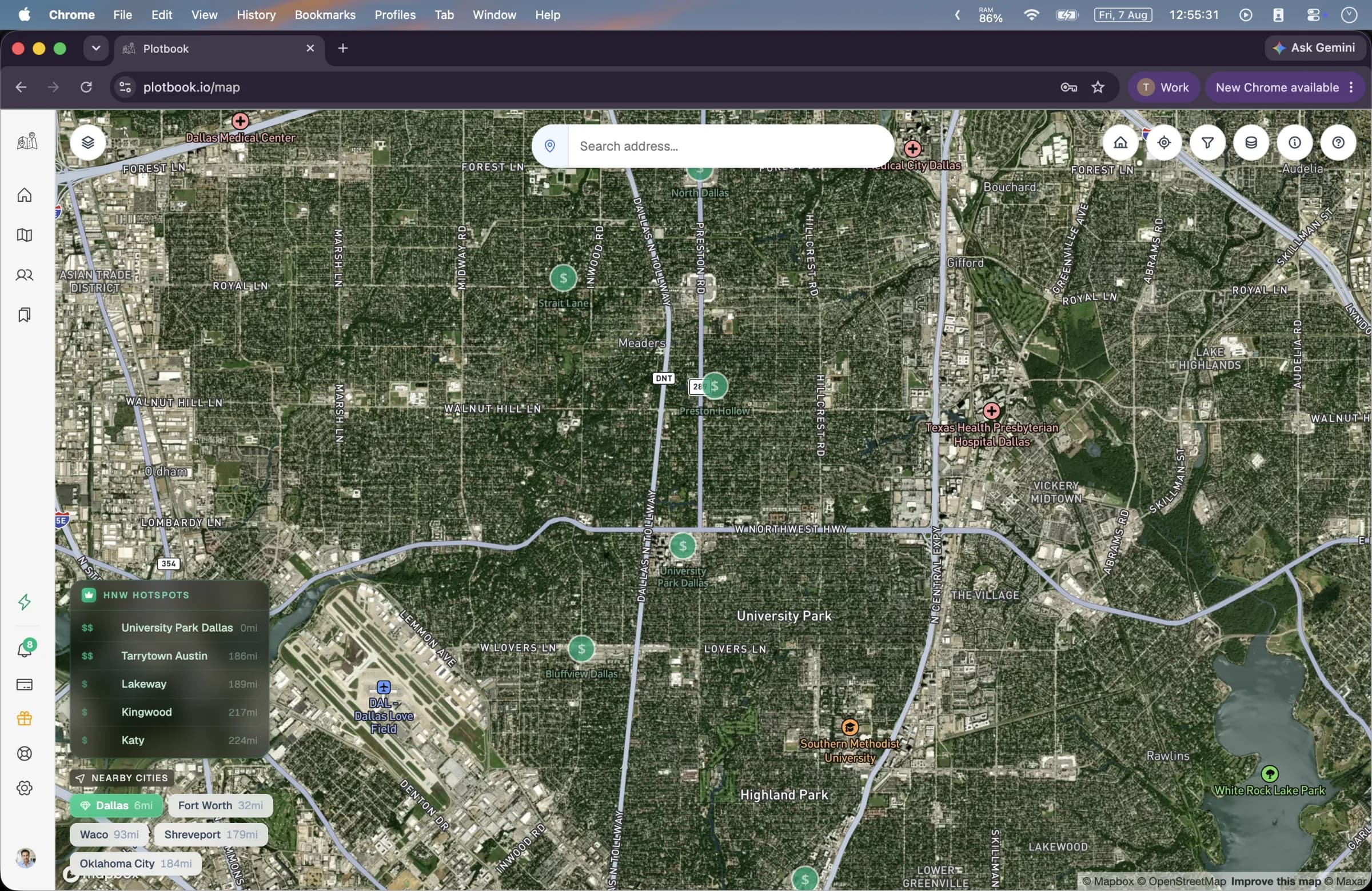
The map changes what it tells you as you move. Far out, it points you at the right markets. Closer, it ranks neighborhoods. At street level, it names names.
- 01
The country
Zoomed all the way out, 232 hand-curated high net worth ZIP codes glow as an emerald heatmap across the United States: Fisher Island, Atherton, Palm Beach, Tribeca, and the places like them. It is a curated dataset built to orient you, so a market you have never worked never starts from a blank map.
- 02
The metro
Closer in, the heatmap resolves into clusters tiered from $ to $$$$ by wealth density, then into pulsing $ badges carrying area names. An HNW Hotspots panel suggests up to five wealthy areas around your viewport, so the enclave one town over never hides from you.
- 03
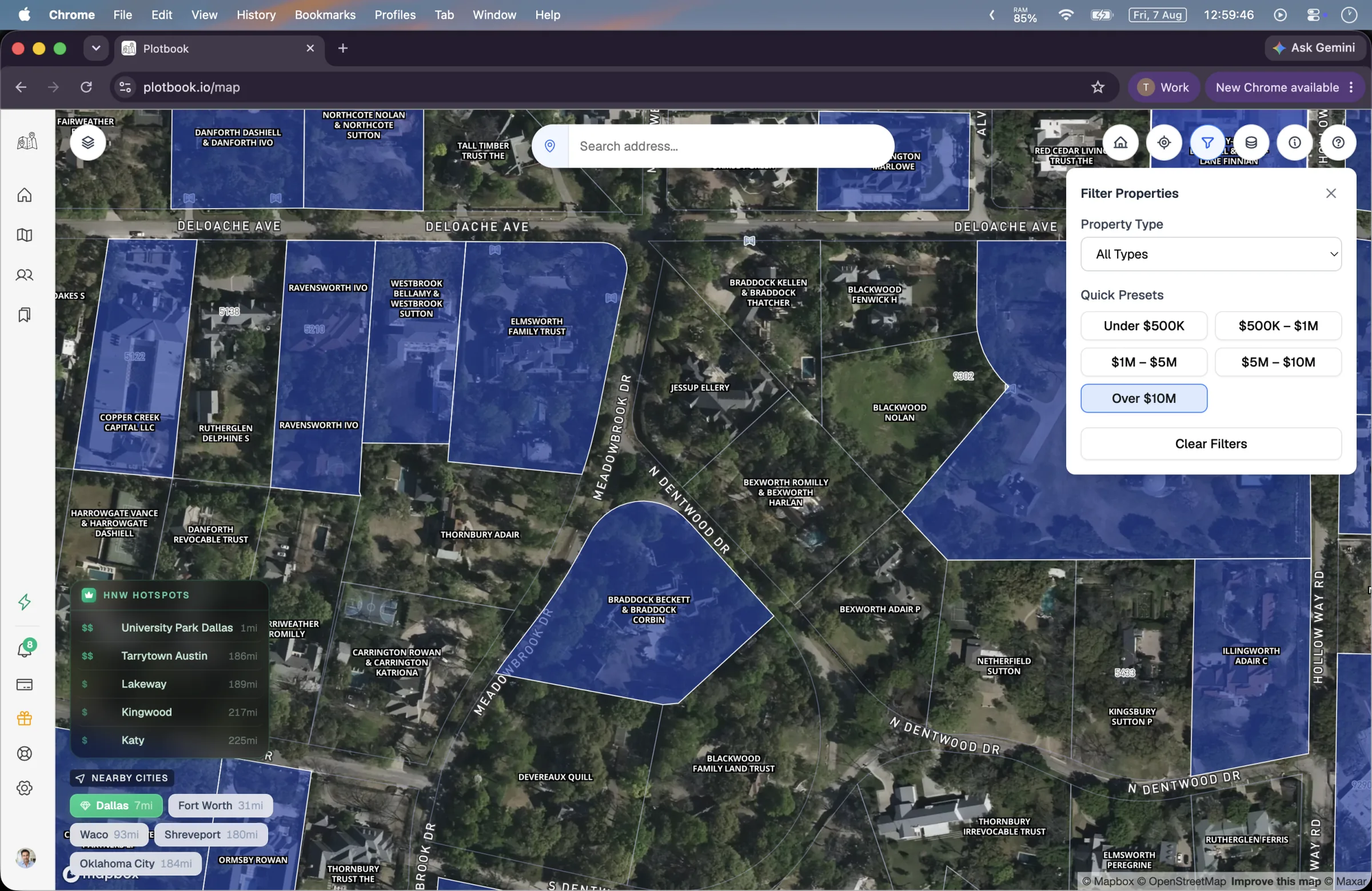
The street
At around zoom 14 the parcels themselves appear, each painted in its value band. Come closer still and every parcel shows the deed owner's name straight off the county record. Large holdings get labeled early, and when labels collide, the highest-value parcels win the space.
The hotspot layer is a hand-curated set of 232 high net worth ZIP codes, maintained as an orientation aid. It marks areas known for concentrated wealth; it does not measure or estimate the wealth of any household.
The value filter
Thin the map to the parcels worth your time
Five quick presets match the value bands, from Under $500K to Over $10M. One tap and the map repaints around your target bracket: an entire metro reduced to only the streets that fit your minimum, in one gesture.
Filtered-out parcels dim rather than disappear. The street keeps its shape, the context stays readable, and any dimmed parcel is still clickable for the moments curiosity wins. Your filter also persists across sessions, so the map opens tomorrow exactly the way you tuned it today.
- Under $500K
- $500K – $1M
- $1M – $5M
- $5M – $10M
- Over $10M
The parcel drawer
Click a parcel, meet the record
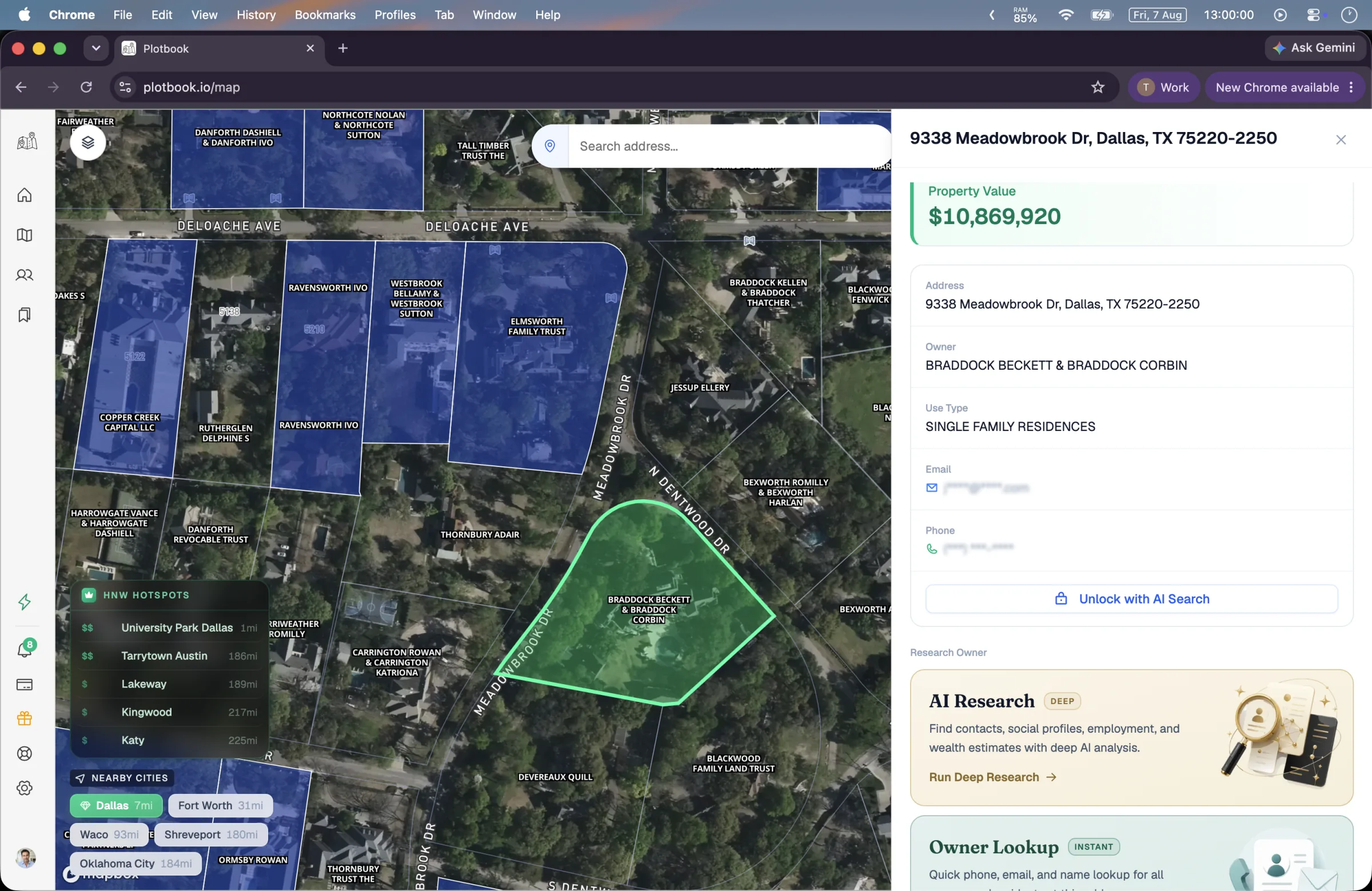
Every parcel opens into a drawer built from the county record: assessed value, full address, use type, and the deed owner's name. Email and phone sit visibly locked until you research them, so you always know which facts are verified and which are still a question.
- Assessed value, address, and use type from the record
- The deed owner, exactly as the county filed it
- Contact fields locked until research earns them
AI Research
An autonomous agent that pierces LLCs and trusts and returns a named, contactable owner with a wealth estimate.
InstantOwner Lookup
A reverse-address lookup that resolves a plainly-deeded home to its resident in a single step.
Owners you save come back to the map as green markers on their linked parcels, so your book of business stays visible on the landscape itself.
Built for every day
The details that make it a daily driver
A map you open every morning has to be fast to read and hard to lose your place in. These are the small decisions that add up.
Nationwide coverage
Nationwide parcel data from Regrid, covering 150M+ parcels, so the map works in your county, not just the famous ones.
Search that keeps up
Jump to any address, city, or ZIP with autocomplete, and your recent searches are remembered for the markets you work every day.
Three basemaps
Satellite for rooftops and lot lines, outdoor terrain for acreage and topography, hybrid when you want street labels over imagery.
Owner names on the map
Zoom in and the deed owner's name from the county record sits on the parcel itself. You know whose street you are on without a single click.
Your book, on the map
Saved profiles with linked parcels come back as green markers, so your pipeline is literally visible on the landscape you prospect.
Filters that persist
Your value filter survives the session. Tune the map to your bracket once and it opens that way tomorrow, until you change it.
See it run
Watch the map workflow, start to finish
From a cold city to a saved prospect: panning the wealth map, filtering by value, opening a parcel, and sending research after the owner.
Full walkthrough, 3 min. All people, contacts and wealth estimates shown are fictional demo data; property records are real public data.
Questions
What people ask before they open the map
Keep exploring
AI Owner Research
The deep path: piercing LLC and trust deeds to a named person.
Reverse Address Lookup
The instant path when the deed already names a person.
Saved Profiles
Where researched owners live, and why parcels turn green.
How the Property Data Works
Where the parcels, values, and owner names come from.
Open the map. Find your next client's roof.
Start in a market you already know and judge the map against the ground truth in your head. The parcels, the colors, and the owners are already there.
New subscribers start with 7 days and 100 credits. We email you before the trial ends.